Mostrando entradas con la etiqueta misterio. Mostrar todas las entradas

jueves, 13 de agosto de 2020

Thor, Kon-Tiki y un misterio que se revela 73 años después


No le creyeron, lo tildaron de loco. En 1947 cruzó el Pacífico en una balsa, desde Perú hasta Raroia, una isla polinesia, para mostrar que era cierta su teoría sobre el origen de los pueblos polinesios y sudamericanos. Setenta y tres años después, la ciencia le dio la razón. Ésta es la historia de Thor Heyerdahl, el creador de la balsa Kon-Tiki.

El noruego Heyerdahl aceptó el reto de la comunidad científica, que afirmaba que era imposible llegar a la Polinesia cruzando el océano Pacífico. El 28 de abril de 1947 él, cinco tripulantes y un loro se subieron a una balsa construida con maderas, cáñamo y hojas de palma rumbo a la Polinesia. 

Moáis, estatuas de la Isla de Pascua

Emprendieron viaje desde el puerto peruano El Callao, tenían por delante casi 4.000 millas náuticas. Tras 101 días —y decenas de peripecias—, llegaron sanos y salvos a tierra. Mostraron al mundo que en la antigüedad posiblemente los sudamericanos habían cruzado el Pacífico en balsa. Sin embargo, hasta ahora no se les había prestado demasiada atención. 

Un estudio de la Escuela de Medicina de la Universidad de Stanford, en los Estados Unidos, y del Instituto de Ciencias Biomédicas de la Universidad de Chile, reveló lazos genéticos entre las islas polinesias y las poblaciones nativas sudamericanas 32 generaciones atrás.

La investigación, que fue publicada en la revista Nature, tomó el ADN de 807 personas de 14 islas de la Polinesia y de poblaciones costeras del Pacífico, desde Chile hasta México. Así comprobó que, como sostenía Heyerdahl, los polinesios tuvieron contacto con pueblos antiguos sudamericanos. Algo que habría ocurrido unos 800 años atrás. 

Viaje de Thor Heyerdahl en la balsa Kon-Tiki

Viaje de Thor Heyerdahl en la balsa Kon-Tiki

Ahora queda claro que la expedición Kon-Tiki fue una hazaña no suficientemente valorada por la ciencia. 

La idea hecha balsa

Heyerdahl bautizó a su nave como Kon-Tiki, un nombre polinesio, al descubrir que en ciertas regiones de Oceanía se adoraba al mismo dios solar que las antiguas culturas preincaicas, al que llamaban Kon-Tiki Viracocha. Además, Heyerdahl encontró que algunos monolitos en la Polinesia se parecían demasiado a los que estaban en Perú. Según se explica en National Geographic, esas coincidencias, le llevaron a pensar que no solamente los asiáticos y europeos podrían haber llegado a los archipiélagos del Pacífico, sino que también pudieron haberlo hecho los indígenas sudamericanos. 

Pesca (imagen referencial)

La teoría de Heyerdhal fue inmediatamente lapidada por antropólogos y científicos de la época, y lo retaron a que él mismo cruzara el océano en balsa. Heyerdhal no lo dudó y estuvo años preparándose para viajar (y buscando a los tripulantes idóneos).

Convenció al artista y navegante Erik Hesselberg, al sociólogo Bengt Danielsson, al experto en radiocomunicaciones y héroe de la Segunda Guerra Mundial, Knut Haugland, a otro experto en transmisiones de radio, Torstein Raaby, y al ingeniero especializado en mediciones técnicas, Herman Watzinger.

Antes de emprender la aventura, el equipo puso rumbo hacia Ecuador en busca de la madera que usaría para la construcción de la balsa, y desde allí viajó hasta Perú donde se fabricaría siguiendo las técnicas antiguas.

"Mi padre nunca tuvo dudas sobre la veracidad de sus teorías. Murió en 2002, a los 87 años, pensando que tenía razón", contó a Viva de Clarín Thor Heyerdahl Jr., uno de los hijos del investigador, desde Noruega.
Thor Heyerdahl posa en el Museo de Kon-Tiki en Oslo, Noruega
© AFP 2020 / STIAN LYSBERG SOLUM
Thor Heyerdahl posa en el Museo de Kon-Tiki en Oslo, Noruega

¿Cómo era Kon-Tiki?

Fue construida con nueve troncos de 13,7 metros de largo y 60 centímetros de diámetro, unidos entre sí con lazos de cáñamo a otros troncos de 5,5 metros de largo y 30 centímetros de diámetro que los atravesaban transversalmente.

  • La balsa Kon-Tiki exhibida en el Museo de Oslo, Noruega
  • La balsa Kon-Tiki raft, en el museo Kon-Tiki en Oslo, Noruega
  • Expedición Kon-Tiki en 1947
  • La embarcación Kon-Tiki, en el Museo Kon-Tiki en Oslo, Noruega

Expedición Kon-Tiki en 1947

La travesía fue registrada en video y en 1951 obtuvo el Academy Award por mejor documental. Heyerdhal también escribió un libro, titulado Kon-Tiki.

¿Quiénes lo apoyaron?

Muchos expertos de la época vaticinaron que era una idea loca, y que la balsa no soportaría el viaje. Conseguir apoyos les resultó difícil. La expedición de Heyerdahl fue financiada mayoritariamente a través de préstamos, aunque también recibió donaciones del Ejército de Estados Unidos en forma de comida enlatada, sacos de dormir y diversos instrumentos de radio y medición, según publicó National Geographic.


El viaje de Heyerdahl a la Polinesia fue el primero de muchos. A partir de ahí construyó los botes de caña Ra, Ra II y Tigris, con los cuales defendió su profundo compromiso con el medio ambiente y la paz mundial. También fue responsable por importantes excavaciones arqueológicas en las Islas Galápagos, la Isla de Pascua y Tucume.

Hoy el Museo Kon-Tiki en Oslo, Noruega, ofrece la posibilidad de sumergirse en la expedición que llevó a cabo Heyerdhal en 1947, la primera de muchas otras que el explorador realizó más adelante: Maldivas, Galápagos, Isla de Pascua (y de las que también se pueden ver una pequeña muestra en el museo).

jueves, 6 de agosto de 2020

El misterio de Kon-Tiki: ¿por qué ahora la ciencia le da la razón?

sábado, 30 de mayo de 2020

El misterio de las Momias de Nazca, por History Channel


¿Un mensaje del más allá?

Un documental avanza sobre las investigaciones de los restos fósiles hallados en Perú en 2017, cuyo origen está en el centro de una controversia científica.

"Momias de Nazca", un documental que intenta dar nuevas pistas acerca del descubrimiento arqueológico realizado en Perú en 2017.

El próximo sábado 30 de mayo, a las 21.50, History Channel estrena Momias de Nazca, un programa especial que investiga el origen de los fósiles de momias de tres dedos encontrados en Perú en el año 2017 y analiza su supuesta vinculación con extraterrestres.


Presentado por el periodista mexicano Jaime Maussan, este documental cuenta con la palabra de distintos expertos -médicos, periodistas, biólogos y radiólogos- convocados desde México, Rusia y Estados Unidos para analizar el caso de los restos hallados en el departamento de Nazca, en Perú.

Hace tres años allí se encontraron cuerpos de cráneos alargados, torsos estrechos y extremidades con apenas tres dedos cada una. Tienen características humanoides, pero a simple vista no parecen cuerpos de la evolución humana.

Las Momias de Nazca, con características humanoides, pero con marcadas singularidades.

En Perú se habló de estos restos como falsificaciones construidas con partes humanas reales. Otros dicen que se trata de la evidencia de presencia extraterrestre en el planeta. Es una controversia aún en disputa.

Mientras algunos exámenes de ADN determinaron que las momias eran efectivamente humanas, otras muestras no pudieron determinarlo. Algunos científicos aseguran que las características anatómicas de la calavera, su estructura interna y las suturas occipitales, parietales y frontales presentes serían muy difíciles de falsificar.

La ciencia aún no pudo dar una respuesta clara sobre las momias de Nazca y es por eso que las versiones y teorías de que se tratan de extraterrestres ganan cada vez más fuerza. Fueron halladas en una tumba ubicada muy cerca de las denominadas “líneas de Nazca” (Perú) y dos de ella, bautizadas como María y Vavita (sería un bebé). Desde su descubrimiento distintos especialistas trabajan sobre sus restos para tratar de explicar su origen.

Momias de Nazca

Maussan empezó en 2017 una investigación científica sobre los orígenes de esas nueve momias de tres dedos. La investigación continúa: este especial da cuenta de su desarrollo y revela los resultados finales de las pruebas realizadas en las momias.

Todo se centra en María, con fecha de carbono de aproximadamente 1.700 años de antigüedad. El trabajo de colocar el ADN de las momias en registros fósiles y compararlo con los humanos modernos y antiguos ha comenzado, y cada hallazgo arroja más preguntas.

El misterio de las momias con tres dedos que podrían ser extraterrestres

Según explicaron los especialistas, el cuerpo de María data del siglo V antes de Cristo (mil años antes de la llegada de los españoles a América), y tiene 23 pares de cromosomas, como el ser humano. Los estudios sobre el cadáver de María pudieron ser realizados porque al momificarlo se utilizó cloruro de cadmio, sustancia que la mantuvo en muy buen estado.

Las Momias de Nazca son el eje de un misterio que todo indica que tardará en ser resuelto.

“Diferentes leyendas señalan la existencia de seres venidos de las estrellas que habitaron entre nosotros. Y este descubrimiento de las momias de Nazca abre la posibilidad de que las antiguas civilizaciones de nuestro planeta podrían haber estado en contacto con seres muy extraños, los cuales, de acuerdo con los análisis de ADN no son similares a ninguna de las especias de nuestro mundo”, asegura Maussan.

Y agrega: “Este hallazgo nos ayudaría no sólo a cambiar el pasado, sino que nos acercaría al futuro de los seres humanos, cuando volvamos a tener un contacto con otros seres inteligentes, una posibilidad que aún parece de ciencia ficción, pero que cada vez está más cerca de hacerse realidad”.

El misterio de las Momias de Nazca fue abordado por científicos de distintas partes del mundo, sin que hayan llegado aún a una conclusión.

Nazca es una zona que envuelve otros misterios, como las “Líneas de Nazca”, figuras que se pueden ver desde el aire trazadas en el desierto de esa región. Se trata de un conjunto de gigantescos geoglifos que forman figuras animales, humanas y geométricas.

Sus orígenes y creación han tenido decenas de teorías, inclusive vinculadas con los alienígenas. Están quienes aseguran que se trata de dibujos realizados por culturas diferentes con el fin de ser “centros de adoración” para las divinidades, o incluso como calendarios. Sin embargo, el escritor suizo Erich von Däniken asoció, en 1968, estas líneas a pistas de aterrizaje para naves alienígenas.

E.S.

sábado, 14 de abril de 2018

Peru is built upon millennia of cultures and their histories.

When the words "ancient Peru" are mentioned, images of Machu Picchu and the Nazca Lines come to mind. But Peru is built upon millennia of cultures and their histories.

The traces they left behind may not be as big as lost cities, but they are no less rare and mysterious. New mummies are breaking old beliefs and revealing new civilizations. Settlements show the realities of the time, invasions, brutal leadership, and even blood sacrifices from otherwise advanced people.

10 The Inca Tree

It was one of those discoveries that surprised everyone because the tree was large and everywhere. Researchers noticed the tall specimens for some time - some grew up to 30 meters (100 ft) tall - but only realized in 2017 that this was a whole new kind of rubber tree.

Relatives to this newcomer include poinsettias and other latex-leaking plants from the spurge family. But the latest addition is truly special - a new genus had to be created to fit the species. It is like finding oak or cabbage for the first time.

Called Incadendron esseri ("Esser's tree of the Inca"), they are a common sight along the Trocha Union, an old Inca road in Peru. The canopy tree carpets the landscape from southern Peru to Ecuador.[1]

Scientists do not fully understand why it appears to be so successful in a harsh environment. But the 0.6-meter-thick (2 ft) Incadendron is susceptible to the planet's rising temperatures and deforestation.

9 Elite Skulls

Around three centuries before the Incas arrived in Peru, the Collagua began to press their skulls into long shapes. This tradition began around AD 1300 and lasted for hundreds of years.

But skull squashing was not for everyone. In a bid to discover why anyone would deform their children's heads, a recent study looked at 211 skulls from two Collagua graveyards. It concluded that the cone people were mostly from elite graves. More surprisingly, skull binding did not develop overnight but was refined over many generations.

Starting in infancy, boards and cloth were used to press the head into increasingly narrow points. Researchers suspect that there was a bond between individuals who looked different from the norm - and that this united leadership was crucial to their survival against the Incas.

The latter arrived in 1450. But instead of going to war, the Collagua elite could have decided to be drawn peacefully into the powerful Inca Empire. Even so, nobody knows what happened to the Collaguas in the end. Similar to their neighbors, the Cavanas, they disappeared.[2]

8 The Paracas Lines

In 2014, archaeologists announced that they found the older cousins of the famous Nazca Lines. Created by the Paracas culture around 300 BC, they were three centuries older than the earliest Nazca design. They were found in the Chinca Valley as part of a complicated artificial environment.

The 71 rocky lines were accompanied by large mounds, pyramids, 353 stone cairns, and rocks stacked in circles or rectangles. Several geoglyph lines and mounds were aligned with the June solstice sunset.

This was no casual worship of the seasons but likely markers to help people from all over find their way to Paracas-style trade fairs at a certain time of the year. It is also believed that the sites themselves held festivities, tracked time, and had other multiple uses instead of any singular purpose.[3]

7 The Atacama Mummies

It is not every day that one discovers 150 mummies from an unknown culture. But between 2012-2014, their simple graves were unearthed in the Atacama Desert.

The individuals were naturally preserved due to being placed directly in the sand, wrapped only in sheaths made of cotton, reeds, or fishing nets. They were not Inca or Tiwanaku because the bodies predated both civilizations by 500 years (4th-7th centuries AD).

Luckily, the grave goods were happy to talk. Most of the items were high quality and decorated. From domestic items, researchers could see how this civilization made jewelry, pottery, and weapons. They also learned what these people wore and that they caught fish and combed their hair.

The discovery of bows was an incredibly rare Peruvian find. Llama bones in another grave could also readjust the history books as to when the animal first arrived in the region.

Remarkably, right next to the cemetery was another graveyard filled with Tiwanaku burials. This later civilization was never thought to have spread their wings as far as the Tambo River delta, where the mummies were found.[4]

6 First Female Governor

In the Chicama Valley stands an ancient adobe pyramid called Cao Viejo. Inside, a mummy rested that changed a big detail about pre-Hispanic Peru. Scholars had believed that women held no power positions. But that changed in 2006 when the so-called Lady of Cao was discovered.

She belonged to the Moche culture, which flourished from AD 100 to AD 800. This woman ruled northern Peru 1,700 years ago. Among the grave goods were a crown, large war clubs, spear throwers, and artifacts of copper and gold. The mummy's face, feet, and legs bore tattoos of spiders and serpents, both magical symbols.

Since she was the first female political, religious, and cultural governor of Peru, researchers wanted the meet the Lady of Cao. The closest they could manage was a facial reconstruction. This happened through skull analysis, 3-D printing, and 10 months of painstakingly weaving all the details together.

The result was a handsome, capable-looking woman in her twenties. A medical examination showed that her cause of death was likely tied to pregnancy complications or childbirth.[5]

5 Flash Inca Invasion

Ayawiri, a town on a hill in the central Andes, was once called home by about 1,000 people. The citizens belonged to the native Colla civilization. When Ayawiri was recently excavated, archaeologists soon sobered up to the fact that the scene was abnormal. Too many valuables were strewn about. It appeared that the inhabitants had left so fast that there was no time to pack.

The amount of valuable metal tools and jewelry, as well as stone implements and useful pottery, is exceedingly rare for an abandoned town. It is believed that Inca warriors descended on the hill with such speed that the Colla dropped everything and ran.[6]

Findings suggested that the event happened around AD 1450 and not everyone was clueless about the impending attack. When excavations reached the homes of the wealthier families, several were almost empty of possessions. Aware of the invasion, they departed earlier. But, for some reason, they chose not to warn the rest of the town. Where the Colla people went after they fled the hill remains a puzzle.

4 Geoglyphs From Three Cultures

Early in 2018, National Geographic broke the news that about 50 new "Nazca" designs were found in Peru. However, these were different from the famous geometric and animal-shaped lines. They were smaller (about the size of a football field), only inches across, and mostly depicted human figures. Unlike the Nazca Lines, which spread across the flat earth, the new images crept up hills.

In 2017, the previously unknown artwork was spotted by drones during a project to conserve the known sites. Their value does not exist only in the visual differences but also in the fact that they were made by three successive civilizations. This showed that the Nazca (AD 200-700) did not invent the tradition.

Instead, they continued what the Paracas started and the Topara culture (500 BC-AD 200) maintained until the Nazca people showed up.[7] It remains a good question to ask: Why did this labor-intensive tradition survive across three cultures?

There are many theories, such as representations of constellations, an aid to pilgrims, or a ritual ingredient. The truth is that nobody knows what drove the ancient Peruvians to create giant images in their environment.

3 Prehistoric Hazing

At the ceremonial site of Pacopampa, skeletons with brutal injuries were found in 2017. Considering the history of the Andes, one could be pardoned for thinking that they were victims of war or sacrifice. But then researchers noticed several things that made it implausible.

Pacopampa had no defenses, which meant that the people there had no fear of being attacked. Their existence must have been peaceful as far as war was concerned. All the injuries showed healing, so nobody died from the horrific blows. Both sexes were equally bashed, none showed defensive injuries (they took the beatings), and the fractures showed up in the same places (skull, face, limbs, and dislocated elbows).[8]

The most important clue came from the fact that none of the skeletons came from elite graves. Everything pointed at a disturbing process. From the 13th to the 6th centuries BC, the ruling class used brutal rituals as a way to maintain their dominance over civilians. Previous excavations had already established that inequality existed at Pacopampa as well as a deep penchant for ceremonies.

2 Chimu Child Sacrifices

The adults at Pacopampa faced nonlethal ceremonies, but some children from the Chimu culture never survived theirs. They were not meant to. In 2017, construction workers were preparing to install pipes when they stumbled upon human remains. Realizing that the bones were ancient, archaeologists were called to the beach town of Huanchaco.

Soon, 77 burials were identified. They were a blend of pre-Inca nations such as the Chimu, Salinar, and Viru. At least 12 were children who died 1,500 years ago. All of the kids' chest bones showed cut marks, as if somebody had sawed at the ribs to remove their hearts.[9]

Apart from the dozen youngsters, there was also a newborn who had been sacrificed. The killings were likely performed by the Chimu culture (AD 900-1470) in a gruesome attempt to please the rain gods. The region was extremely dry.

In a stark contrast, the Chimu people are remembered for their advanced crafts and engineering. Their capital, Chan Chan, is recognized by UNESCO as an "absolute masterpiece of town planning."

1 Living Royal Incas

The last Inca emperor fell in 1533 when he was murdered by the Spanish. Atahualpa had ruled the biggest empire of its time and the culture that produced engineering treasures such as Machu Picchu and a 40,200-kilometer (25,000 mi) network of roads from Colombia to Argentina.

After the emperor's execution, the empire was obliterated. Dutch Historian Ronald Elward moved to Peru in 2009 and spent years looking for any royal descendants. He identified 25 noble family names directly linked to Atahualpa.

Remarkably, most living descendants showed up in the lower social groups. This could be because indigenous surnames are preserved in rural areas but frowned upon in the cities.

One woman traced by Elward was 40-year-old Roberta Huamanrimanchi Tupahuacayllo. During the day, she looks after other people's children. On her mother's side, Roberta inherited royal Inca blood. Her father collects family skulls, an ancient Inca tradition.[10]

Elward's research was supported mainly by parish records and interviews. In turn, it provided the groundwork for Peruvian geneticist Ricardo Fujita. Testing those who claimed descent from Atahualpa's father, Huayna Capac, DNA linked around 35 people to indigenous populations near Lake Titicaca. This supports the myth that the Inca originated in that region.

sábado, 16 de diciembre de 2017

Sayhuite Monolith: Can You Solve the Mystery of the 200 Designs Carved by a Forgotten Creator?


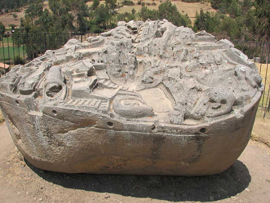
Long ago, forgotten artists put their blood, sweat, and possibly even tears into creating more than 200 designs on a monolith in what is now Peru. They carefully engraved the forms of reptiles, felines, shellfish, and frogs and then surrounded the sacred animals with terraces, ponds, river, tunnels, and irrigation canals. The exact purpose and meaning behind these features remains a mystery.
Sayhuite is a pre-Columbian archaeological site located in Abancay, a province in the southern-central Peruvian region of Apurímac. This site has been dated to the period of the Inca Empire, which flourished between the 15th and 16th centuries AD. Compared to other Incan sites, little has been left from the time of the Incas at Sayhuite. The most noteworthy object at Sayhuite is the Sayhuite Monolith, a mysterious boulder with lots of little carvings on it.
The Sayhuite monolith. ( Public Domain )
The name ‘Sayhuite’ is said to have its origins in the Quechua word ‘saywayta’, which translates as ‘place of orientation’. Located on the top of a terraced hill called Concacha, the site was once home to an enclosed sanctuary. All that remains of this sanctuary today is its raised platform, on which the Sayhuite Monolith may be found. According to some scholars, this site was one of the four sanctuary oracles of Apurimac, known also as the ‘sons’ of Pachacamac. There is, however, at present, a lack of archaeological evidence to establish the veracity of this claime.

Sayhuite Archaeological site (overview). (AgainErick/ CC BY SA 3.0 )
Unique Carvings
The Sayhuite Monolith is not the only carved stone in the area. In the valley below the site, there are a group of carved boulders known collectively as Rumihuasi (which means ‘stone house’). The carvings on the Rumihuasi monolith may be described as geometric, and consists of either steps and / or canals. The Sayhuite Monolith, on the other hand, contains not only carvings that are geometric in design, but also zoomorphic ones. Therefore, whilst it is not the only carved rock in the area, it is undeniably the most unique one.
The Sayhuite Monolith measures about 2 meters () in length, and 4 meters () in width. Although the stone may be found today on the raised platform on top of Concacha, scholars are not certain as to where it might have originally been placed. As the monolith is not a natural rock outcrop, it may have been transported there. The boulder seems to have been moved, perhaps by looters, sometime in the past. Apart from the question of its original location, scholars are also unsure as to who made this object.
In any event, the Sayhuite Monolith has attracted much attention thanks to its carvings. On the upper surface of the monolith, one may observe over 200 zoomorphic and geometric figures. The majority of the former are said to represent reptiles, felines, shellfish, and frogs. Some scholars have argued that the choice of these animals has a symbolic meaning that would have been comprehended by the Incas. For example, the felines may have been a reference to the Incan capital, Cuzco, and its elite, especially Pachacuti, the ninth Sapa Inca, and the first ruler of the Inca Empire.
Drawing showing the zoomorphic and geometric figures on the Sayhuite monolith. ( Maestroviejo)
Interpreting the Designs on the Monolith
Apart from zoomorphic figures, there are also geometric carvings on the monolith. These have been interpreted as representations of terraces, ponds, river, tunnels, and irrigation canals. If this were the case, then it may be said that the stone represented a scale model of the landscape. Some have even taken this interpretation further by suggesting that the Sayhuite Monolith was used as a topographic model for hydraulics. According to this theory, the monolith was used by the ancient Incan engineers as a model to experiment and observe the flow of water, which would then be implemented in public water projects. Moreover, such a model could have been used as a pedagogic tool for other engineers and technicians in this trade.

video del Monolich Sayhuite


jueves, 12 de octubre de 2017

Origin Myths of the Inca Civilization & Piecing Together Royal Heritage


According to most historical accounts, especially those collected by the early Spanish chroniclers of the 16th century, and just after the destructive efforts of the conquistadors, the Inca were believed to have originated in the area of Lake Titicaca, south of present day Cusco, Peru. More specifically, archaeological evidence suggests that the Inca developed as a cohesive group on the Island of the Sun and Island of the Moon on what is today the Bolivian side of Lake Titicaca, as well as the nearby town of Copacabana. This is thought by many scholars to have begun around 100 BC to 100 AD.

Lake Titicaca, Peru (Public Domain)

Over the course of the next number of centuries, the Inca evolved as a rather complex society, especially in regards to agricultural cultivation, mainly in the form of terracing systems called Andene. Almost the entire Island of the Sun was developed with these Andene, which can be witnessed to this very day, though they are largely no longer in use.

Andenes at Moray, Peru. ( CC BY 3.0 )

The Navel of the World

Lake Titicaca was once part of the Pacific Ocean, and over the course of millions of years, due to friction between the Pacific and Nazca tectonic plates, it slowly rose to its present elevation of approximately 13,000 feet. Slowly, over time, the saline content of the lake was reduced from millions of years of rainfall, and a major or several major tectonic shifts caused the Altiplano area to tilt, rising in the north and sinking in the south. The last of these catastrophic movements likely occurred between 45,000 and 12,000 years ago, creating the largest salt flat in the world at Uyuni, south of Lake Titicaca, and shrinking the lake’s size by 90 percent.

The Search for the Tomb and Treasure of the Last Inca EmperorGod’s Gate and the Sun Temple: A Mysterious Incan Portal Leading to Other Worlds

The Salar Salt Flats of Uyuni (Public Domain)

The lake still has a high enough salt mineral content that the water cannot be used for irrigation, and that would have been true during Inca times as well; thus, they were dependent on rainfall to water their crops. Around 900 to 1000 AD, there was a 40-year drought, the result of local climate change, perhaps exacerbated by an excessive El Nino event, which put great hardship on the Inca people. This was further complicated by the invasion of indigenous Aymara Natives, who plotted to, and eventually ran the Inca out of the territory.

Again, according to most accounts, especially those of the Spanish chronicles, the Inca then ventured north, and over the course of time established themselves in what was to become their capital city of Cusco. In the Inca language, called Runa Simi which means the “peoples’ voice” and not Quechua which most presume, Cusco means “navel”, and was the navel or core of their world from its inception to the destruction by the Spanish in about 1532 AD.

Inca terraces at P'isaq. (Public Domain)

Children of Viracocha

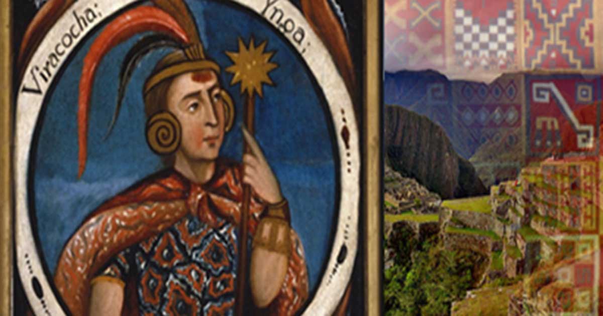
Oral tradition states that the Inca “rose from the waters” of Lake Titicaca at the behest of their creator God Viracocha, who had previously made a race of giants, but they were stupid and cumbersome, so he destroyed them in a great flood. In most of the accounts four pairs of twin brothers and sisters were created, the two most prominent of them being Manco Capac (royal founder) and his sister/wife Mama Ocllo, who became the first official Inca rulers, likely by the time they reached and established Cusco.

Viracocha (Public Domain)

Another account, taught to the author by Cusco-based anthropologist Dr. Theo Paredes, is that this first ruler’s name was Mallku Capac, which could be translated as “of royal wisdom.” Dr. Paredes, who is an expert of the Runa Simi Inca language believes that the reason why the Inca first arrived in Cusco was not that they had been chased out of the Lake Titicaca area by the Aymara people, but that ancient wisdom keepers, who were carriers of very ancient traditions lived in Cusco, and that Mallku Capac had to go there to complete his education in order to become the first high Inca.

Part of the Inca Trail system (Public Domain)

In other legends, Manco Capac (also known as Ayar Manco) was the son of Viracocha of Paqariq Tampu (six leagues or 25 km south of Cusco). He and his brothers (Ayar Auca, Ayar Cachi and Ayar Uchu) and sisters (Mama Ocllo, Mama Huaco, Mama Raua and Mama Ipacura) lived near Cusco at Paqariq Tampu, and they united their people with other tribes encountered in their travels. They sought to conquer the tribes of the Cusco Valley, and these legends also incorporate an important golden staff, thought to have been given to Manco Capac by his father.

jueves, 4 de mayo de 2017

The Sayhuite Stone - A massive boulder with over 200 Geometric and zoomorphic figures

Located at the Sayhuite archaeological site in Peru - around 3 hours away from the city of Cusco - we find one of the most mysterious boulders in Peru.

According to experts, this archaeological site was a sanctuary related to the cult of water, where a temple existed that legends describe as being covered with gold sheets of the thickness of a hand, and while many archaeological remains have been found there, the strangest one of all is the Sayhuite stone - a massive rock covered with more than 200 geometric and zoomorphic figures.

When the Spanish conquistadores arrived in Sayhuite - according to John Hemming in his book Monuments of the Incas - the temple was ruled by the priestess Asarpay who, before being captured, threw herself from the top of a 400-meter high waterfall.

The remains of the temple show no traces of the gold, but the entire archaeological site is covered with massive andesite blocks and stairways that offer a small glimpse into the past as if they belonged to a much larger construction that existed there at one point.

But let's get back to the Sayhuite stone.

The most mysterious blocks on the site is without a doubt the Sayhuite Stone - a huge monolith on which the ancients carved hundreds of geometric and zoomorphic reliefs, such as reptiles, frogs, and felines. The stone is about two meters long and four meters wide.

It was found at the top of the Concacha hill, and experts believe it was used as some sort of topographic model for hydraulics. Carved on the stone you can clearly distinguish terraces, ponds, rivers, tunnels and irrigation canals.

While the exact function of the Sayhuite stone remain a mystery, researcher Dr. Arlan Andrews believes that this monolith was used as a scale model to design, develop, test, and document the properties of water flow for public water projects, and to instruct ancient engineers and technicians in the concepts and practices of the craft.

Experts believe that the stone has been remodeled several times, and the ancients added and removed several elements, changing the water flow.

While there are several theories that describe its function, many experts agree that the massive stone most likely had a religious use, perhaps a symbolic representation of the universe, and or related to the cult of water. Whoever created the massive stone is another massive mystery. Although it is known for sure that the place was an Inca sanctuary, archaeologists are not sure that the ancient Inca were the constructors.

It has been speculated that it could also be a representation of the irrigation system used by the Incas and even a scale model of their entire empire with each of the regions represented with certain symbols. The jungles would be represented by the presence of animals like monkeys, iguanas or jaguars, whereas the coast is symbolized with animals like octopuses.

While the Sayhuite stone remains shrouded in mystery, it provides archaeologists with insight into the culture of the pre-Columbian population. Archaeologists have determined that the site was an Incan religious center, where rituals and ceremonies for the worship of water was conducted. The monolith is an important clue to this since it depicts a water-like flow between the carvings.